
|
|
''If I don't get a storm today I will go mad'', these are the words I said to Roisin on the morning of July 5th ahead of a brand new chase day. I had been suffering the storm blues thanks to the worst thunderstorm season I have ever experienced in my life, the thunder drought and chasing fix I badly needed had not come to pass after months of patience and fragile self control and now it was getting to the point that my frustration was having a big emotional effect on my life, that's how much I enjoy storm photography. After a cold early Spring and Summer with grey weather the models changed in a major way signaling what could be a significant heat wave and outbreak of storms. A Spanish Plume was looking very likely with insane CAPE charts and high temps which triggered great excitement within the storm community and with building anticipation and tension I began to wonder if my long wait would end in explosive fashion, there was no question about it, the charts looked incredible with some of the finest energy I have seen. After a build up of a week I began to fear that the plume would shift east - 9 times out of 10 it does - and instead favour all of Britain. Well that's exactly what happened with lesser CAPE in more capped air for Ireland in comparison to the explosive potential across the water.
The UK ended up getting a late evening cap break which generated 4 or 5 supercell thunderstorms which trekked across NE England producing golf ball hail stones which smashed car windows, funnel clouds and awesome lightning displays which lasted well into the night. That day the cap never broke across Ireland however we did get fantastic warm and humid weather with temps of 27 C while England got 37C with unofficial stations recording higher in some locations. The second day looked a little better for Ireland when the cap broke in the S midlands producing a few elevated thunderstorms however they died out when they moved towards the N hitting more capped air, this was yet again another let down however I was thankful that on both days I didn't get tempted to chase anyway so I saved diesel money, sometimes it's good to hold back and avoid the temptation to go, I had listened to my instincts and they kept me grounded, in a way I was grateful for I didn't relish a long distance drive in this humidity. That night we had a brief clearance and I watched the close conjunction between planets Venus and Jupiter low in the NW, both looked like golden stars, one above the other, proudly shinning within the hazy twilight sky while above was a formation of altocumulus castellanus clouds reminding me of the storms that never were. It was 20 degrees C at midnight, I loved filming the planets at night in a t-shirt and standing in my socks in the garden, I could get used to that.
The following day looked a little better with good wind shear, the cap broke early and heavy showers formed below the border heading N toward Fermanagh so I decided I could hold back no longer, I needed to get a chase out of my system, so I threw caution to the wind and went chasing, just as I left TORRO had issued a convective discussion for tornadoes so that was encouraging. However on the road down I knew things were not good, grey cirrostratus cloud and mid level gunge had shut off solar heating, this was the main trigger and without it surface based storms would not fire. I arrived in Belleek in time to catch those showers, they looked weak and low topped as they approached the lakes, at one stage there was an interesting lowering however after careful observation it turned out to be an outflow feature. I got a wifi signal and the radar informed me those cells had died as they moved towards the border hitting capped air, there wasn't a convective cloud visible in any direction and I knew the road trip had been in vain, this was the third cap bust in a row, I ended up taking video of two sorry looking Donkeys standing in heavy rain which pretty much summed up how I felt, however being an optimist I made the best of the situation by finding new roads I had never been on before then going for a scenic drive around Lower Lough Erne and stopping off to visit Tully Castle and Monea Castle which really made my day. I drove back N and visited the McDonalds in Omagh and enjoyed a well deserved Aero McFlurry which was absolute heaven, my mouth was dry after such a long day on the road. The insects got my attention on the way home with what seemed like millions of them smacking into the windscreen, I kept hearing tap tap tap tap on the glass from countless impacts, I pulled over near Desertmartin and got images of an OK sunset over a field of cows, these were the only images I got after more than 9 hours on the hunt, but that's storm chasing for you, I knew my luck was about to change though so I swore never to give up.
July 5th had much better potential and I had a good feeling about it, this was a more typical set-up with low pressure close by aiding lift with little in the way of a cap in a nice SWly slack fetch with colder air aloft and 800 CAPE to work with, however higher resolution models indicated CAPE values of more than 1000 and Lis of -3. There was little in the way of wind shear however some parts of the country had some increase in winds with height, so all in all it looked like a fun day with a chance of pulse storms and perhaps a multicell or line with unstable air already present first thing in the morning, all we needed was solar heating and storms should fire. Roisin and I where based in Cookstown and woke up early on Sunday morning at 08.30 to check the models and forecasts. By 09.00 I could see big towers growing far away to the SE from the backyard and I knew from the sight of those towers that this day would produce storms. After a quick breakfast we checked radar which showed that an early morning storm had fired with sferics over Monaghan with the parent cell moving N towards the border, it was heading for Armagh sporting a large and strong radar signature, we wasted no time and hit the road. By the time we reached Dungannon we realised the cell was spent, the precip was weak and there were no more strikes. We waited around for some time and things were not looking good with grey cloud and overcast skies with a big drop in temperature, it was clear that the cloud and outflow from that cell had cut off all solar heating in this area so we needed to find a location where clear skies would allow good heating to take place. I used the chance to top up on diesel while we waited on nature to make its next move.
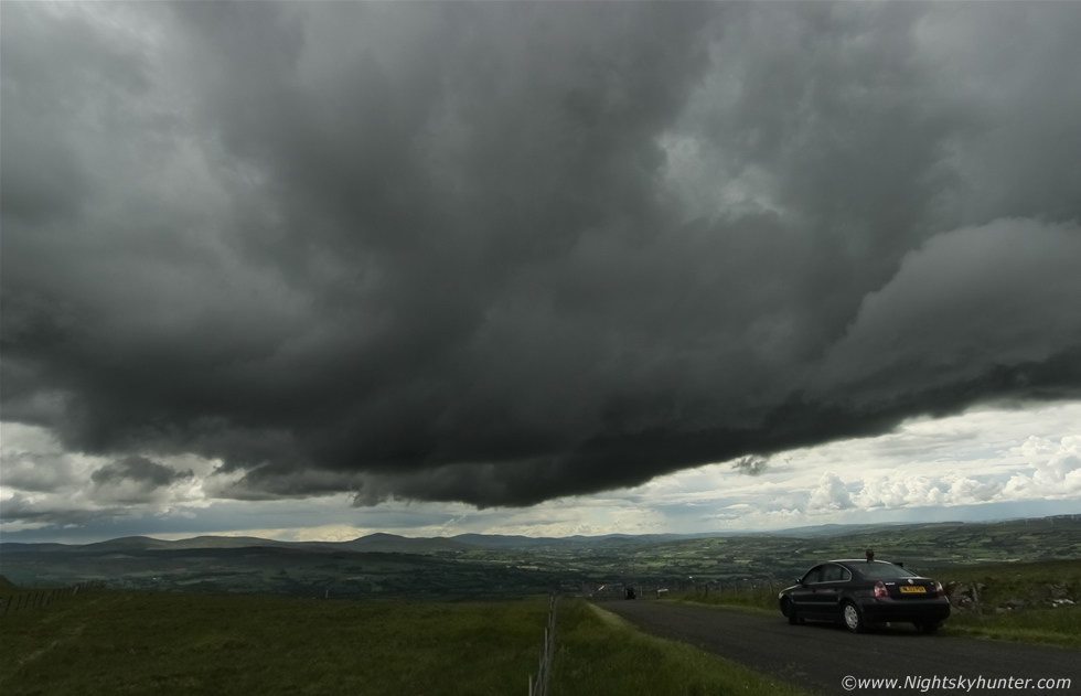
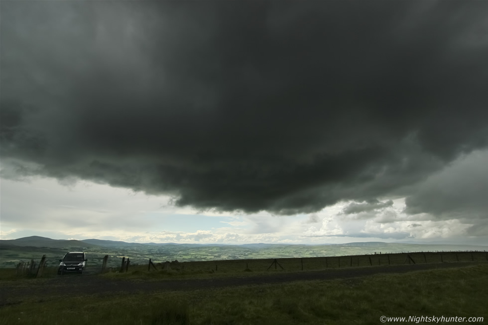
We took a break and had an early lunch at the garden centre on the Dungannon road then relocated to Cookstown to monitor the skies from the Omagh road. Visually the sky looked much more impressive to the W and N, there were clear skies there and soon we saw several towers going up in the sunlight with keen looking mushroom tops, these looked like storms firing, we decided to move in that direction so we drove NW back towards my home area, a place which never lets me down and were the sky was definitely 'talking'. We stopped at Oak Leaf filling station and got wifi to check radar, I was delighted when I saw the latest update, storms had fired in the very area where we had seen those towers with a long line of cells running S to N from Omagh and Strabane all the way across the western Sperrins into the N with c-g sferics already present on the S cells, it was action time, we took off immediately across Glenshane Pass and from there we could see that line of cells dominating the W sky. The cells were in various stages of their life cycles, some were dying while others were blooming into life, the cell to the N looked the strongest however I also wanted to get into position to watch the S cells too in case of surprises. Roisin suggested Benbradagh since it offered a fantastic viewing point which had done us proud before, it sounded good to me, so we drove half way up the mountain and set the gear up.
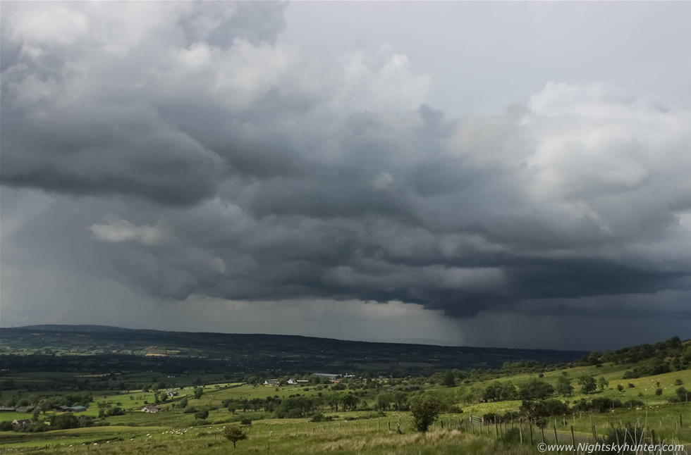 |
A linear formation of convection crossed the sky, everything was slow moving and very stagnant, I knew this was going to be a waiting game so I set up the Go Pro in a field and began doing a long time lapse of the growing storm clouds. We watched and waited, and waited some more and waited again, the sky seemed to take forever to do something, the clouds were just creeping across the landscape at a snail's pace then after one hour of careful watching I spotted developments to the NW, that area of the line had a stronger looking cell and as I watched the precip core seemed to intensify and turned dark, Rosin said ''well, anything happening?'', I said there was a storm trying to form to the NW, Roisin went for a jog down the mountain while I watched the skies, then suddenly a deep rumble of thunder disturbed the mountain solitude, a storm had fired exactly where I had mentioned, in the distance Roisin stopped her run and waved her hands in the air shouting ''thunder'', I gave her the thumbs up, our patience had been rewarded. The storm stirred for a long time with random rumbles of thunder as it moved across Limavady then passing to the E of Lough Foyle heading for the N coast. I was in my element sitting on the grass in the warm gentle breeze watching this storm mature and rumble, here's an image with the Canon 24-70mm F/2.8 lens showing the storm crawling L to R heading for the coast.
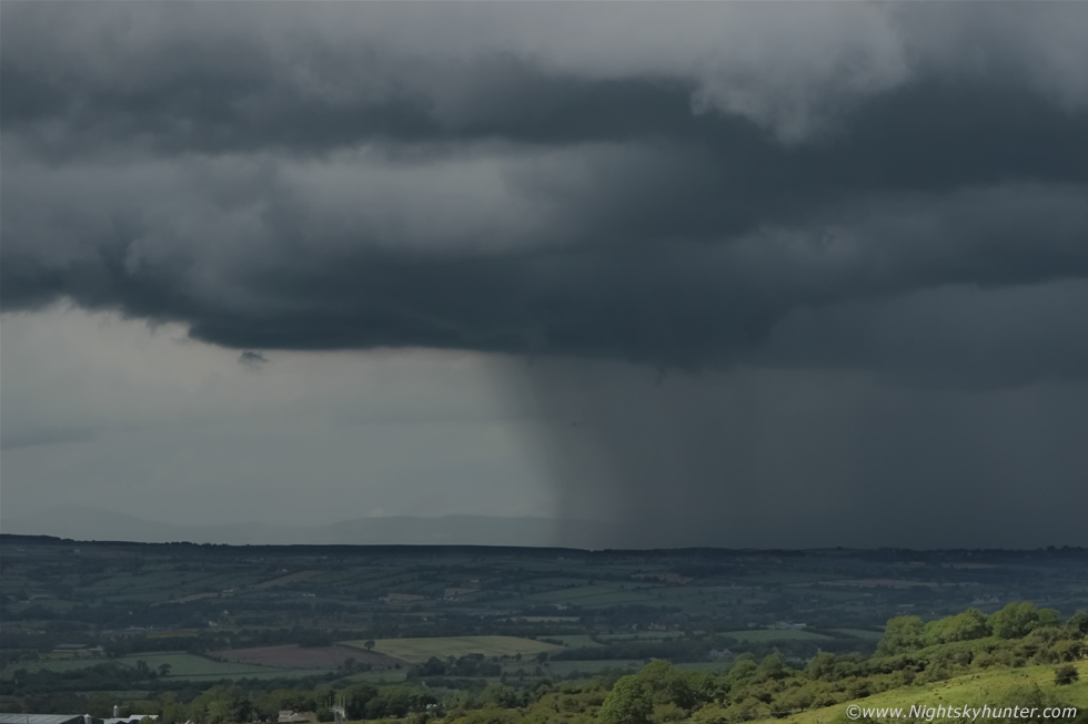 |
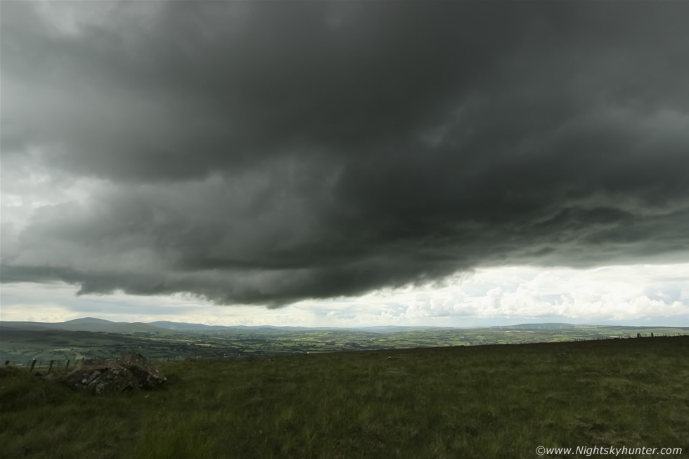
70mm shot of the dark base and precip core, when it hit the beach to the N the coastguard had to clear the beaches due to lightning in that area, it seemed people on the beach were oblivious to it and didn't realise they were in danger of being struck. Paul Martin text me to say that Portrush was about to get slammed going by the latest radar. I looked behind me and noticed very interesting new developments back in the SW, the S side of this line was exactly what I wanted in view and turned out my instincts were correct. A narrow black base had formed, then seemed to grow in vertical extent and getting heavy and mean looking, I knew I was watching the birth of a new storm, I was tempted to leave here and go after the N coast cell however it was already mature and this new one looked much more interesting, it was just a cloud and invisible to radar however I had a good feeling about it. Another wait began then the late afternoon heat seemed to intensify and that seemed to give the clouds a sudden push and within min's I was seeing several tall updraughts bubbling up high over head and attached to that growing dark base, its amazing to watch the birth of a storm and watch the entire process in front of you, I knew this cell was going to do it rite here for us, it was just a matter of waiting. Hazy sunshine lit up tendrils of scud cloud under the black base, which had now passed overhead and behind me, and as I watched the clouds were revealing good inflow motion and small areas of rotation, it looked like a funnel could form at any minute, I also noted convergence happening with cloud moving in from the N meeting the SW flow, perhaps a sea breeze or local effects caused by wind movement across the mountain. We got back in the van and drove under the base, out the other side, then up to the very peak of the mountain and stopped beside the gate.
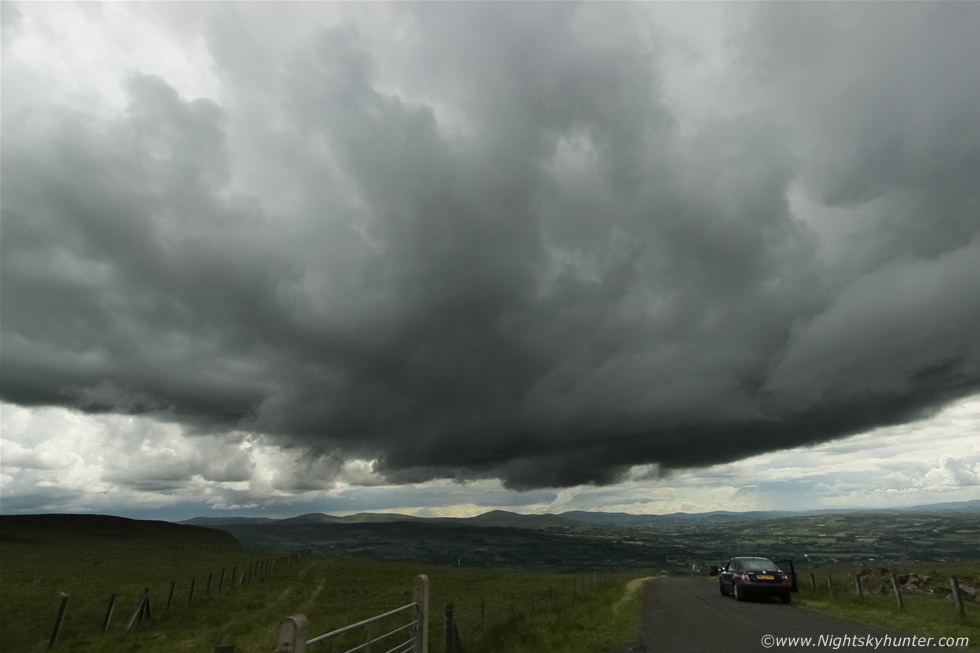 |
Half an hour later the cell was taking on an impressive profile in the form of a big updraught base perched over the mountain hovering in full view against a backdrop of the Sperrin mountains, check out the structure in this 10mm wide angle image, this the portion of storm where funnel clouds and tornadoes can form, I was glad we had remained faithful to this cell. I could see scud rising slowly upward into the building updraught base and small vortices of cloud swirling into it too, the cell was feeding on the moist warm air and I knew it would announce itself soon.
 |
This car made for a good sense of scale for the image, base barely moving L to R , I don't know if the driver in the car was there to watch the storms too, he certainly had his eyes to the skies anyway.
 |
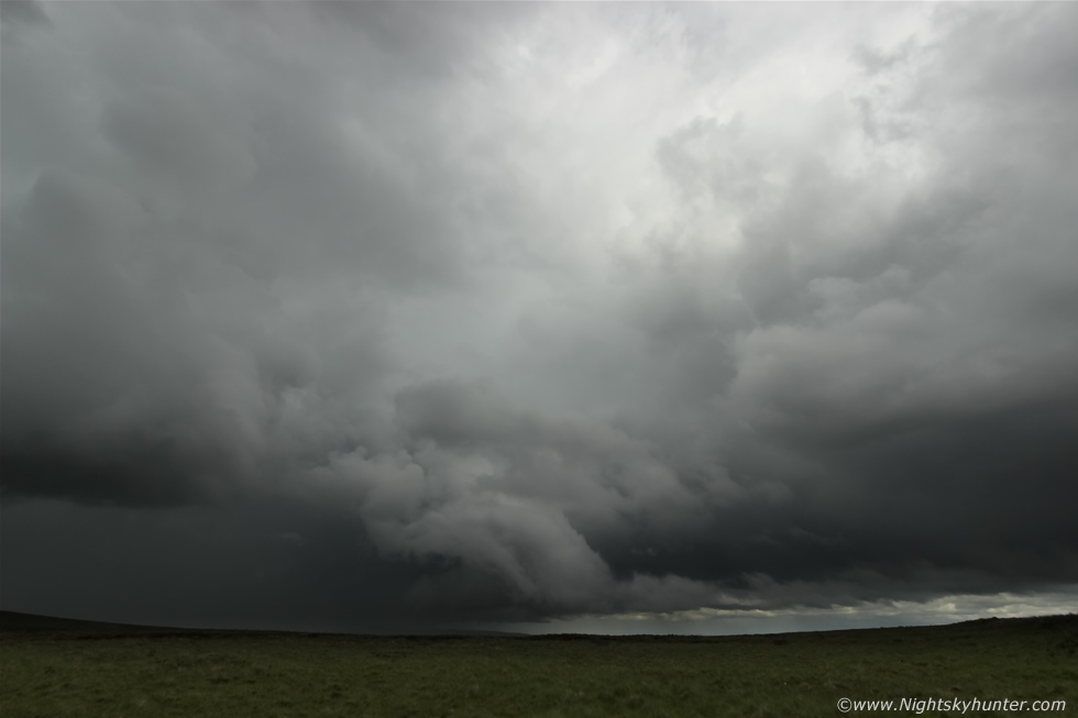
I climbed over the wire fence and walked into a field, set-up the Go Pro for a short time lapse, took a few more images, then knelt down on the grass to take in the view. The underside of the base had nice texture as sunlight beamed down from above illuminating more towers far away in the distance. 20 min's later I felt the first drops of rain falling on my head, I could sense the building charge in the atmosphere and realised I was a lightning hazard so I packed up the gear and went back to the van, then it let loose its first rumble of thunder, it was now a storm, what a build up!, we had watched this storm build itself cloud by cloud into this big hungry cell which took well over an hour to organise, that felt very satisfying.
 |
The base moved overhead and the precip core became very active, this is facing N and moving L to R with random rumbles of loud thunder getting more frequent with time. Sporadic in-cloud bolts lit up the core from inside so I did some hand held filming (outside) with the DSLR at 10mm and set up the Samsung video camera on a fence post for a time lapse, I was enjoying this personal encounter with the storm despite taking a big risk being out in the open, much of the lightning was I-C and in the core so I was confident I would be fine. I watched the rain cooled air undercut and lift the cloud ahead of the storm as the outflow scooped up the warm moist air in front.
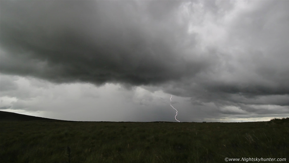 |
A few cloud to ground strikes appeared, the dangerous kind, here's a grab from the 10mm DSLR footage, it struck somewhere beyond the ridge on the hill
 |
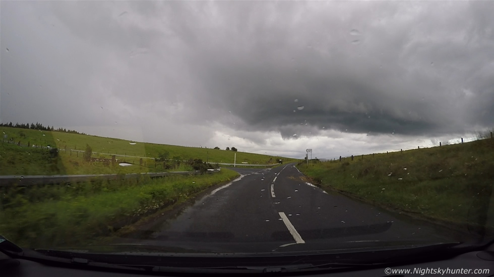
Panning around behind me for a shot of the updraught base which was now passing over my van. Hail stones began to fall in greater number and I sensed an increasing lightning threat and decided I had took enough chances and ran back to the van, once inside a very good hail core fell on us with 1/2 cm stones bouncing of the van bodywork with a clang. The storm was moving N so we decided to give chase, we went back down the mountain and took a back road through Dungiven heading in the general direction of Coleraine.
 |
Chasing the storm on the mountain road, what a view, the updraught looked quite impressive with nice sculptured structure, this looked like a storm with some wind shear, the base is to the R and the precip core is well vented to the L. The above image was taken from the wide angle Go Pro footage.
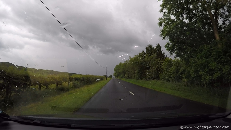 |
As we approached the outer portion of the core we got treated to some great lightning, here's a nice in-cloud bolt whip lashing the sky with a hint of pink colour. We punched through the core and got into extremely heavy rain and small hail stones, the roads were water logged within min's, visibility dropped rapidly and the monsoon-like rain drummed so loudly on the van we couldn't hear the thunder outside. I was filming with the Go Pro on its window mount and Roisin was filming with the other video camera, it was good team work. We began to laugh with excitement, this core turned out to be much more intense than any of us had expected, it was quite crazy for a while with parts of the road flooded and great waves of water spraying up against the side windows as we drove through.
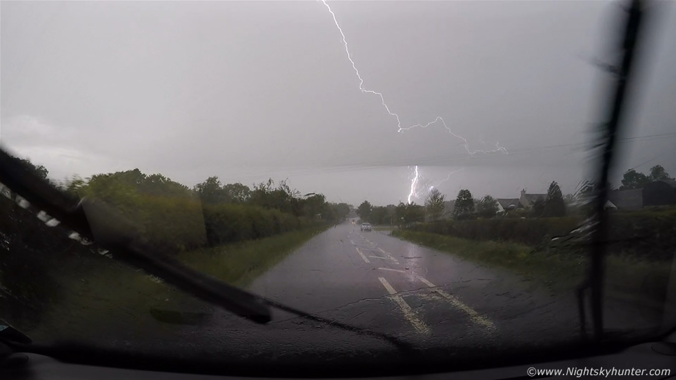 |
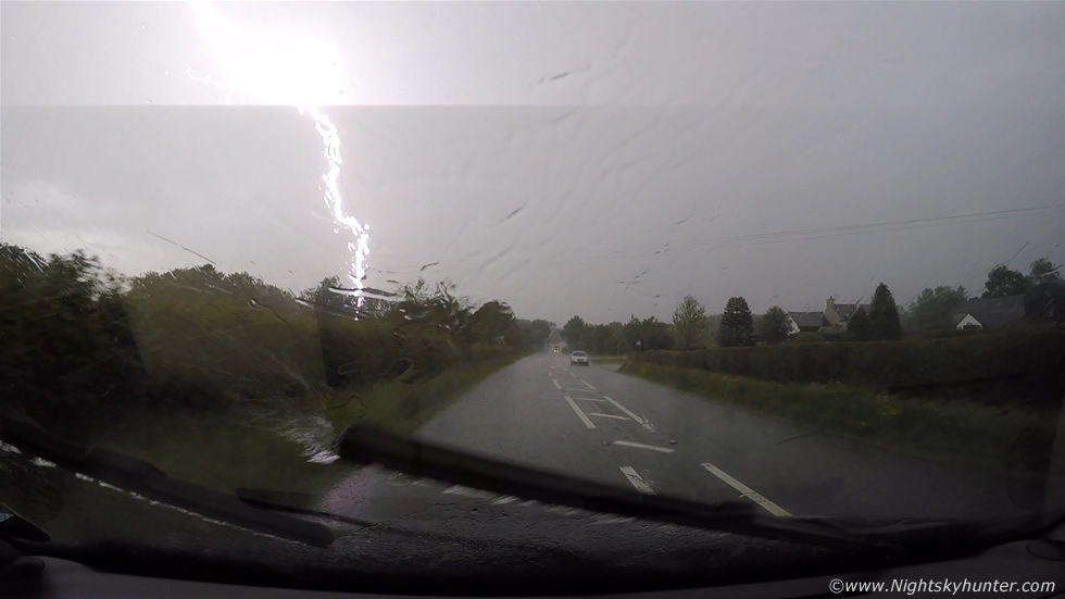
While heading N outside Garvagh I had just switched on the Go Pro again when two rapid fire c-gs struck the ground one after the other at close range, the bolts took up the entire windscreen field of view with blazing blue-white colours, Roisin and I yelled with excitement, the scene was awesome and was without doubt the highlight of the chase, I just recalled I had turned on the Go Pro however the lightning happened so quickly I doubted I had it recorded. It was only when we got home later that I found out I had the thing on camera!, to say I was overjoyed would be an understatement. This is why I now use the Go Pro for storm chasing, first of all it can catch events while you can drive safely and second of all it as a high frame rate for slow motion video, mine was recording at 48 frames/sec, you don't need this for normal video as 30 frames/sec is sufficient, however the faster frame rates would be good for catching daylight lightning bolts, this was one of the reasons why I wanted the Go Pro, now it had proven itself perfectly in the field for I had captured both bolts in different frames. Here's the first c-g striking to the R of the road, check out the bolt illuminating the saturated road with its brilliance.
 |
The closer c-g striking on the other side of the road, these were very close strikes, remember the field of view in these cameras is very wide which makes subjects look more distant.
Here's video footage of the two bolts striking with slowed down sections, this clip is a good example of just how dangerous lightning can be even from non-severe storms. We followed the storm through Coleraine then the lightning seemed to stop or at least we couldn't hear the thunder anymore then finally ended the chase at Portrush looking across a calm sea. Unknown to us at the time this storm had caused significant flooding in Ballycastle where it even damaged a bridge which made it onto the news, to think that two hours earlier we had watched the sedate birth of this very same storm from Benbradagh, a full life cycle observation.
Full chase video over 20 min's long showing the storm base, lightning, precip core and time lapse segments, best watched in full HD. We stopped off near Garvagh on the way home and bought a few late evening snacks, Roisin and I sat outside the van eating our well deserved food with blue skies and warm sun on our faces while clean white convection bubbled up beside us, I couldn't have been happier, all my favourite things together around me. It was a fun chase which ended the long thunder drought, however I was hooked and felt in top form and wanted to do another chase as soon as possible, the natural high and feel good factor from doing this stuff is hard to shake, I wanted to feel that buzz again that only comes from mother nature. Little did I know that when we returned back there was a convective outlook issued for Ireland the following day for a risk of low topped supercells and tornadoes, however I will save that story for the next report. Thanks very much for reading.
Martin McKenna